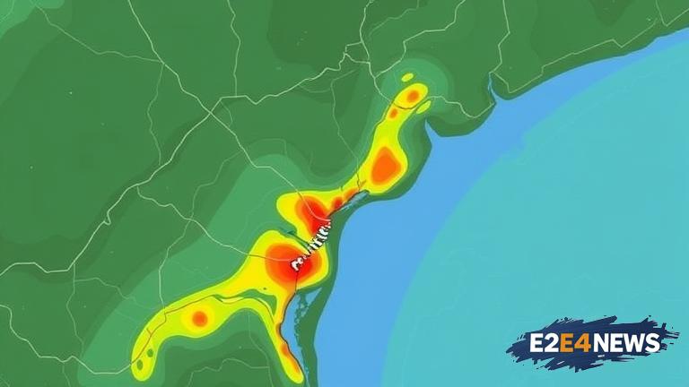
A recent investigation has revealed that the Federal Emergency Management Agency (FEMA) removed dozens of buildings from the 100-year flood map at Camp Mystic, a popular summer camp in Texas, before a major expansion project. The removal of these buildings from the flood map has raised concerns among local residents and experts, who argue that it may have been done to facilitate the expansion plans. According to records, FEMA made the changes to the flood map in 2020, just months before the camp’s expansion project was approved. The expansion project, which included the construction of new buildings and facilities, has been valued at millions of dollars. The removal of the buildings from the flood map has significant implications, as it may have reduced the flood risk designation for the area, making it easier for the camp to secure funding and permits for the expansion. However, critics argue that the changes may have been made without adequate consideration for the potential flood risks, which could put people and property at risk. The 100-year flood map is a critical tool used to determine flood risk and inform development decisions. It is designed to show the areas that are most likely to be affected by flooding in the event of a 100-year storm. The removal of the buildings from the map may have been done to reduce the perceived flood risk, making it more attractive to developers and investors. However, this decision may have been made without adequate consideration for the potential consequences, including the risk of flooding and damage to property. The investigation has also raised questions about the transparency and accountability of FEMA’s decision-making process. The agency has faced criticism in the past for its handling of flood map revisions, with some arguing that the process is opaque and prone to political influence. The controversy surrounding the Camp Mystic flood map revision has sparked calls for greater transparency and oversight of FEMA’s decision-making process. Local residents and experts are demanding that the agency provide more information about the decision to remove the buildings from the flood map and to explain the rationale behind it. The incident has also highlighted the need for more robust flood risk management strategies, including the use of more accurate and up-to-date flood mapping data. Furthermore, the controversy has raised concerns about the potential impact on the environment and the local community, including the risk of flooding and damage to nearby homes and businesses. In response to the controversy, FEMA has announced that it will conduct a review of its flood map revision process, including the decision to remove the buildings from the Camp Mystic flood map. The agency has also pledged to increase transparency and accountability in its decision-making process, including providing more information to the public about flood map revisions and the rationale behind them.